European data on animals aloft now publicly available
Weather radars detect more than weather, they also continuously register the movements of billions of animals (birds, bats, insects) in the air. Those data are now publicly available for large parts of Europe, providing coverage of the aerial habitat in a way no other method can.
This post was originally published on Springer Nature Research Communities.
Billions of flying animals move through the air, day and night. Due to the scale, volume and high altitudes, the scope of these movements are hard to study through observations or biologgers. Weather radars however continuously monitor the sky across large areas, registering not only weather, but also the movements of animals in the air. Archives of weather radar data are therefore goldmines for biological monitoring, providing an overview of the year-round activity of animals in the air in a way no other method can. Even though weather radar networks exist in many countries, they are usually operated on a national basis so combining biological data from several such networks across Europe has been a decade-long challenge.
We have now processed and published the first large-scale datasets of biological activity in the air, derived from weather radars across a large part of Europe. The radar data were obtained from the Operational Programme for the Exchange of Weather Radar Information (OPERA) at EUMETNET and three national meteorological services. The resulting datasets are a major milestone for the aeroecology community and the result of long-term interdisciplinary collaborations in the projects ENRAM, GloBAM and HiRAD.
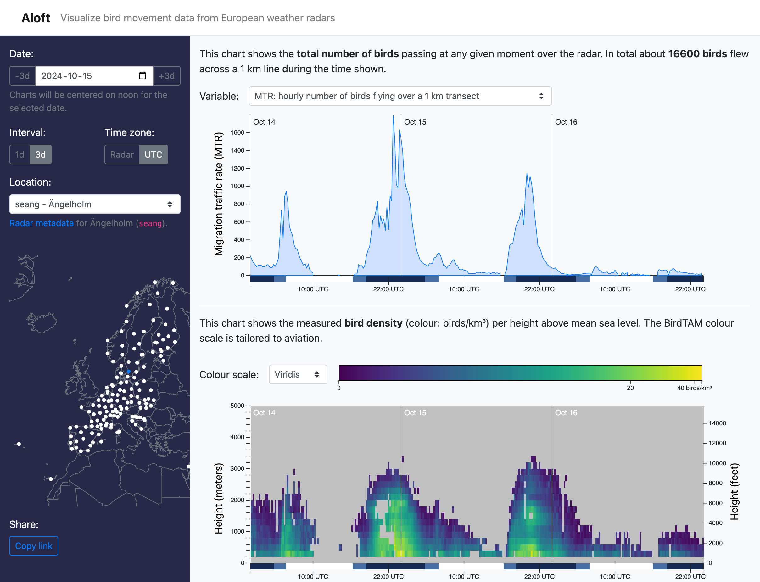 Visualization of biological activity in the air, derived from radar SEANG in Ängelholm, Sweden (see blue dot on map). The charts show data from October 14 to 16, 2024. The top chart depicts the number of birds flying over the location per hour. The bottom chart shows at what altitudes the birds are flying (yellow = high density). Explore the data yourself at crow.aloftdata.eu.
The data consist of measures of all biological activity in the air surrounding the radar stations, stored as vertical profiles that describe the amount, speed and directions of animals at different altitudes. These were obtained by processing weather radar data with dedicated and validated methods for detecting birds and especially bird migration, but the data in itself do not offer any distinction between birds, insects or bats, so it must be interpreted through biological knowledge of what species groups are expected to be moving during different periods and places. Likewise, careful consideration of the variation in data coverage and quality is necessary. For more information on the intricacies of this exciting new datasets, we have provided usage notes in our paper.
The paper describes two public datasets that collectively contain biological data from 141 radar stations in 18 European countries, from the years 2008 to 2023. You can download these data from Zenodo or explore and visualize them in our Aloft data portal at aloftdata.eu. The portal is also updated daily with new data.
Weather radar data gives us a glimpse into life in the air, shedding light on the movements that take place above our heads. It has great potential to be used for conservation efforts, such as mapping where and how high birds fly in relation to anthropogenic threats, mapping diseases that spread along flyways, and highlighting periods of high bird activity for flight safety applications. These new datasets offer tremendous value for researchers studying flying animal movements and for enthusiasts simply witnessing these aerial spectacles. We look forward to seeing the creative, important and urgent applications that emerge as these biological data reach the wider scientific and conservation community in the coming years.